Thursday, November 13, 2014


Dichotomy in the Desert

Lightning over Vegas (1)
Southern Nevada, and pretty much all of Nevada sits in a gigantic rain shadow. The massive Sierra Nevada Mountain Range sucks up a majority of the moisture coming in to Nevada. The precipitation that is allowed in Southern Nevada is mostly dispersed on the high mountain ranges that run north-south. This dichotomy can be seen in average precipitation; Mount Charleston receives around 24 inches a year. Snowfall at the ski resort averages “99.5 inches”. (2) Whereas just fifty miles away in Vegas the “Average annual precipitation - rainfall: 4.17 inch”.(3) Cloudbursts can occur in the Vegas Valley; and these storms can accumulate in an hour as much rain that it would take a whole year to acquire. One can ski in the morning time at 11000 feet, and then walk down the strip without a jacket.

Summers are very long with short mild winters. “Las Vegas, Nevada has a subtropical desert / low-latitude arid hot climate (Köppen-Geiger classification: BWh)”. (4) BWh is also the rating of the Mojave desert in which Vegas lies. The isogeotherm ranges in the mid-sixties. Throughout the year the temperatures range from 120 to 30 degrees. The climate is extremely dry and humidity very low. This is a perfect place to use a swamp cooler. The extreme variations in temperature may seem unbearable but without the humidity plus a cold beer one can adjust.
Climograph of Las Vegas averages. (3)
Sunset over Mount Potosi. Cumulus clouds refract the sunlight in a gorgeous manner. (5)
 
References
4.http://www.las-vegas.climatemps.com/
5. Picture courtesy of William Benjamin Canipe


Tuesday, October 14, 2014


Hydrology of Southern Nevada

Lake mead from Frenchman mountain. Notice the mass wasting and soil creep on the mountains closest. You can also see some debris at the base.
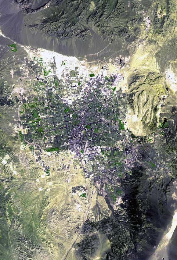
The Indian may have had the right idea when conducting a rain dance, without the sacred water there is no life. Southern Nevada is a place where not only is hydrology the source of life it is also a major shaper of the land.  Lake Mead was formed to harness the power of the Colorado River but also has become the life source of Las Vegas. Now at an alarming rate the lake is being funneled of water. The three natural springs that Mormon settlers developed have long been run dry. To the west are the Spring Mountains still  playing true to their name there are many natural springs. Also in the mountains to the west of the valley torrential rains can bring flooding to the city. Looking from space it is very easy to see that the Vegas Valley is an alluvial fan with the famous strip being at the center. The ground is not porous and thus the water does not percolate into the ground. Streets become gushing rivers within minutes. This causes mass wasting, debris flows, and mudslides.


Las Vegas Valley from space, notice the alluvial fans to the north, the dry drainage basins, and all the mountain streams converge at the center. (courtesy of Wikipedia and International Space Station)


One very interesting thing about Southern Nevada is that one used to be able to watch Nuclear Bomb blasts from downtown bars; this testing has caused a negative impact on the hydrological system.“From January 1951 through September 1992, 828 underground nuclear tests were Conducted at the Nevada National Security Site (NNSS; formerly the Nevada Test Site). Depths of these tests ranged from 30 to 1,500 meters below the ground surface with approximately one-third of these tests being at or below the groundwater table." (FS.FED). The future of this landscape will be determined by the exploitation or conservation of the hydrology.


References

Picture Number one: courtesy of William Canipe
Picture number two: http://upload.wikimedia.org/wikipedia/commons/6/64/Las_Vegas_Satellite_Map.jpg

Picture number three: courtesy of William Canipe


Tuesday, September 16, 2014

Introductory blog GEOG 1202


The awe-inspiring landscape of Southern Nevada


Looking west towards Mount Charleston. Photo taken on east side of Vegas valley.


This picture was taken 15miles west of the Las Vegas Strip in the Red Rocks Conservation Area


August 28th 2014
Howdy y’all! My name is William Canipe; I am a pre-Business major currently attending the University of Colorado Denver. I am a sophomore. I took this class because I believe business and geography coincide in many ways. Born and raised in Colorado. Ever since
I was a child I've had an addiction to maps, globes, things that show how immense and complicated our world is in a geographical sense. Through out this blog we will dive into the world of Southern Nevada, no not the gigantic casinos but the even bigger geographical backdrop that surrounds Las Vegas. This area interests me mainly because two words, mountains and money. Two hobbies of mine are mountaineering and gambling. I have visited Vegas and traveled the mountains that surround quite a bit. One thing most people don’t know is that Southern Nevada isn’t all deserts. A haven pops out of the valley at 11,916 feet. Mountain Charleston is only 32 miles from Las Vegas but can have snow on the top while temperature in the valley soars as high as the mountain. 


Top picture is a beautiful snowy scene in Southern Nevada. Bottom picture is a snow man I made while hiking the Mount Charleston wilderness. Elevation 9000 plus feet. May 2013.
 
References/Images:
No references used for this blog.
Images courtesy of William Canipe.